Heceta Head
Coastal headland in Oregon, United StatesHeceta Head is a headland that stands 1,000 feet (300 m) above the Pacific Ocean in Lane County, Oregon, United States. The Heceta Head Light is located on its south side. Heceta Head is named after a Basque explorer under Spanish commission, Bruno de Heceta, who explored the Pacific Northwest in the 1770s. The headland marks the end of a lower-lying stretch of the coastline to the south dominated by sand dunes; the coastline to the north is more varied. Devils Elbow is the bay south of the headland at the mouth of Cape Creek, and with the headland formed Devils Elbow State Park, which is now part of Heceta Head Lighthouse State Scenic Viewpoint.
Read article


Top Questions
AI generatedMore questions
Nearby Places

Big Creek Bridge (Oregon)
United States historic place
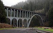
Cape Creek Bridge
United States historic place
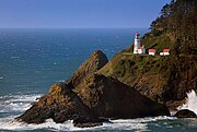
Heceta Head Light
Lighthouse in Oregon, United States

Sea Lion Caves

Carl G. Washburne Memorial State Park
State park in Oregon, United States

Muriel O. Ponsler Memorial State Scenic Viewpoint
State park in Oregon, USA
Big Creek (Lane County, Oregon)
River in Oregon, United States
Cape Creek
River in Oregon, United States